What Is a Weather Radar?
A Weather Radar is a radar used to observe cloud movements, rainfall patterns, snowfall, and other meteorological phenomena.
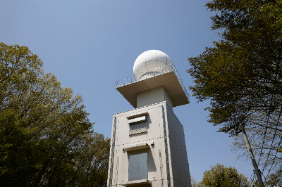
Meteorological agencies install weather radars in various locations on the ground, and airports are equipped with weather radars as well. Additionally, radars installed in aircraft serve the function of weather radar.
Weather radar emits radio waves into the atmosphere, and upon reflection from clouds or precipitation, the returning radio waves are received by the antenna. The time taken for the radio waves to reflect allows for the calculation of the distance to clouds or precipitation. The strength of the returning radio waves is used to determine the intensity of rainfall.
By analyzing the phase shift between emitted and received radio waves, it is possible to observe whether clouds or precipitation are approaching or receding. This phase shift, known as the Doppler effect, is utilized in Doppler radar.
Uses of Weather Radar
In the aviation industry, weather radar is employed for the safe operation of aircraft. Ground-based weather radar observes cloud movements within a radius of approximately 120 km, ensuring that hazardous clouds are not approaching during aircraft takeoff and landing.
Particularly beneath cumulonimbus clouds, strong downdrafts are likely to occur, and air traffic controllers take precautions, such as suspending aircraft takeoffs and landings, when cumulonimbus clouds are approaching near runways. On the other hand, weather radar installed in aircraft allows observation of clouds in the direction of travel.
If cumulonimbus clouds are ahead of the aircraft, pilots will alter the course. When turbulence is anticipated upon entering the clouds, pilots advise passengers and crew to take their seats and fasten their seat belts.
Principles of Weather Radar
Radar echo images display distributions such as the position of rain clouds and rainfall amounts, enabling the estimation of meteorological phenomena. Echo images can observe meteorological phenomena not visible in visible and infrared cloud images from weather satellites. In echo images, precipitation is often classified by color, allowing for the estimation of rainfall patterns from intensity distributions.
The temporal changes in echo images reveal the characteristics of meteorological phenomena. Colored areas are referred to as precipitation areas, and the onset and movement of precipitation areas are used to estimate weather patterns.
Types of Weather Radar
There are primarily five types of weather radar: microwave radar, millimeter-wave radar, Doppler radar, polarimetric radar, and lightning radar.
1. Microwave Radar
Analyzes electromagnetic waves reflected by crystals such as rain or snow to observe the density and position of precipitation like snow and rain. It uses electromagnetic waves with a wavelength of 3 to 10 cm.
2. Millimeter-Wave Radar
Analyzes millimeter waves with a wavelength of about 1 mm to 10 mm, similar to microwave radar.
3. Doppler Radar
Observe frequency shifts due to the Doppler effect by emitting radio waves. It can measure wind direction and speed and observe the flow and movement of air and clouds on a fine scale. It is suitable for observation during rough weather, but in clear weather, wind cannot be observed as there are no raindrops.
4. Polarimetric Radar
Emits both horizontal and vertical polarized waves and determines precipitation intensity by the difference in the reflectivity of the waves.
5. Lightning Radar
Analyzes reflected electromagnetic waves and can also observe lightning.
How to Choose Weather Radar
Weather radar selection depends on factors related to observation and estimation.
1. Microwave Radar
Observe shadow areas that are challenging to observe due to obstacles, making them suitable for installations in mountainous areas. It has become compact and lightweight and is also deployed on weather satellites, which are less affected by ground obstacles due to their wide observation range.
2. Millimeter-Wave Radar
With a shorter wavelength, it can observe small objects and is suitable for observing particles in fog and cloud droplets. It is used not only in ground-based installations but also on weather satellites.
3. Doppler Radar
Grasps wind direction and speed to observe the flow and movement of air and clouds on a fine scale. It is suitable for observation during rough weather, but in clear weather, wind cannot be observed as there are no raindrops.
4. Polarimetric Radar
Less affected by factors such as raindrop size and transmit power, allowing for quantitative observation.
5. Lightning Radar
Since thunderstorms interfere with other observations, their use is limited. For lightning observation, a separate radar may be installed.