カテゴリー
category_usa

Aerator

What Is an Aerator?

An aerator is a tool used for perforating the lawn, creating pathways for air to flow. This process is known as aeration.

There are two methods of aeration: “spiking” and “core aeration.”

Spiking involves using an aerator called a “lawn spike” to manually puncture holes in the lawn. This method is convenient and suitable for areas of the average household size.

Core aeration, on the other hand, uses a specialized tool to penetrate the lawn and extract portions of the soil. While it takes more time compared to spiking, it is highly effective. New soil is typically added to the locations where the soil is extracted.

Additionally, automatic aerators are now available, eliminating the need for manual operation.

Uses of Aerator

Aerators are used when perforating the lawn.

The reason for creating holes is to prevent the soil beneath the lawn from becoming oxygen-deprived, which can lead to reduced permeability. Once the lawn is established, it becomes challenging to cultivate the soil beneath it. Consequently, the soil gradually becomes compacted, leading to root suffocation. To prevent this, pathways for air circulation are created, and the soil may be exchanged with fresh soil.

Through aeration, benefits such as supplying oxygen to the soil, improving water drainage, stimulating root metabolism, and preventing diseases and issues can be achieved.

In essence, aerators are used to supply oxygen to the soil, alleviate soil compaction, and promote the growth of the lawn, all to enhance the soil’s health.

カテゴリー
category_usa

Altimeter

What Is an Altimeter?

Altimeter

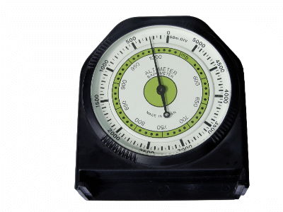
An altimeter is an instrument used to measure altitude.

There are three methods for measuring altitude. Among them, the barometric altimeter, which measures altitude based on atmospheric pressure, is predominantly used. Even in small aircraft and training planes, only barometric altimeters are installed.

As atmospheric pressure fluctuates with time and location, it is necessary to calibrate the altimeter using the latest information. Caution is needed in areas where atmospheric pressure drops, such as mountainous regions.

The remaining two types of altimeters are the radio altimeter and GPS. The radio altimeter relies on a transmitting antenna and a receiving antenna attached to the underside of the aircraft. Radio waves are sent from the aircraft to the ground, bouncing back to the receiving antenna.

Uses of Altimeter

Altimeters are used to measure the altitude of aircraft and spacecraft. Pilots of aircraft need to constantly be aware of their current altitude, making altimeters highly valuable.

While the barometric altimeter is always in use, the radio altimeter cannot be used when the distance from the ground is too great. Therefore, it is frequently employed during takeoff and landing or when flying at low altitudes, especially in poor visibility conditions.

Aircraft are generally considered to fly well at altitudes around 10,000 meters. This figure varies depending on weather conditions and factors like engine combustion and air resistance. Altimeters play a significant role in maintaining an altitude of around 10,000 meters.

Principles of Altimeter

The altimeters used in aircraft are the radio altimeter and barometric altimeter. The radio altimeter uses radio waves to measure the time it takes for reflections from a target, displaying the distance. The barometric altimeter measures atmospheric pressure, converting it into altitude for display.

For mountaineering altimeters, the barometric altimeter is commonly used. When combined with a compass and a map, it helps determine the current location, aiding in pacing during mountain climbs. The altimeter also serves as a barometer, reading changes in atmospheric pressure to confirm weather patterns.

If the atmospheric pressure rises from the evening to the next morning, the weather is expected to improve, while a descent in pressure indicates worsening weather conditions.

Structure of Altimeter

Altimeters can be classified into analog and digital types.

1. Analog Type

It measures altitude using an aneroid barometer that senses pressure. It is simple in functionality, user-friendly, and easy to maintain. There are solar-powered altimeters available, eliminating the need for battery replacement. However, caution is required as the needle may move with slight vibrations.

2. Digital Type

It offers higher accuracy compared to analog types, suitable for quickly obtaining detailed numerical values. It utilizes the piezoresistive effect, where electrical resistance changes with pressure, and is therefore called a piezoresistive altimeter. Digital altimeters often include weather and temperature prediction features, providing comprehensive preparedness. However, most digital altimeters are battery-powered, requiring attention to battery levels.

Types of Altimeter

For mountaineering altimeters, there are primarily three types: handheld, wristwatch, and app-based.

1. Handheld

Various types can be used as a compass or map. They are compact, ensuring ample space in your belongings, and size considerations are minimal. Altimeters that can be taped to the car interior are particularly suitable for driving. Adjustable altimeters with screws allow for accurate altitude measurements.

2. Wristwatch

Always worn, reducing the risk of loss, and there is no need to retrieve it from a bag. Many wristwatch altimeters are waterproof. Recently, altimeters with solar charging functions and those capable of measuring heart rates have also been introduced.

3. App-based

Apps with altimeter functionalities have been developed. This means that carrying only a smartphone enables you to accomplish almost everything. However, attention is required for battery levels and sufficient storage.

How to choose an Altimeter

Altimeters come with various features depending on the intended use. For mountaineering, waterproof and compass features are crucial. Additionally, having temperature, GPS, and solar charging functions adds an extra layer of assurance.

カテゴリー
category_usa

Wheel Chock

What Is a Wheel Chock?

Wheel Chock

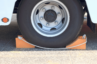
A wheel chock is an item used, quite literally, to stop wheels in place, such as in parking spots or garages. It becomes necessary when the spot or garage is inclined, preventing the vehicle from moving on its own. Wheel chocks are not limited to cars; they also exist for railway vehicles and aircraft.

The size may vary, but they are typically around 50 cm in length, 13 cm in width, and 8 cm in height. They are wedge-shaped, and crafted from materials like wood or lightweight polyurethane.

In the context of aircraft, wheel chocks are also known as “chocks.” Therefore, the process of attaching wheel chocks to an aircraft is referred to as “chocking” or “chocking operation.” The individual responsible for choking is called a “chockman.” The chockman attaches wheel chocks when the aircraft arrives at the spot and removes them just before takeoff.

Uses of Wheel Chock

Wheel chocks are attached to wheels to prevent the unintentional movement of various vehicles, including aircraft, railways, and automobiles.

While some may feel it unnecessary, it can prevent major disasters in situations like brake failures or when the parking spot is inclined. It proves useful in these “what if” scenarios. Additionally, wheel chocks are effective during strong winds or adverse weather conditions.

However, it’s important to note that if wheel chocks are forcefully applied and jammed too tightly, they may become challenging to remove later, requiring caution in their use.

Furthermore, some engage in activities like reusing chocks and transforming them into charms for students praying for success in exams. This practice is symbolic, as the term “chock” implies anti-skidding, aligning with the wish for students not to “slip” during their exams.

カテゴリー
category_usa

Guide Bar

What Is a Guide Bar?

Guide Bar

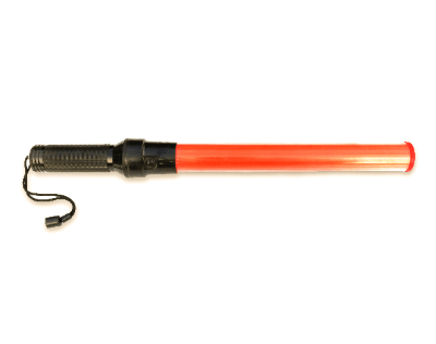
The term “guide bar” refers to a rod used to guide aircraft. It is also known by the name “paddle.”

There are two main types of guide bars: rod-shaped and spatula-shaped. The spatula-shaped version is traditional, but recently, the rod-shaped variety that can be used day and night has become mainstream. The predominant colors are mainly yellow or orange.

Individuals working with guide bars are called marshals, and their profession is referred to as marshaling. Marshals communicate signals to pilots by adopting specific poses regulated by ICAO (International Civil Aviation Organization). For example, raising both arms high indicates the start of guidance, while making a large “X” overhead signals a stop.

Effective coordination between marshals and pilots is crucial to facilitate tasks such as loading and unloading luggage smoothly.

Uses of Guide Bar

The primary use of the guide bar is, quite literally, to guide aircraft. When guiding aircraft to designated locations specific to each aircraft model during takeoff and landing, marshals use guide bars. Performing tasks without holding anything would make coordination with pilots difficult, so guide bars in conspicuous colors such as yellow or red are used.

Pilots of aircraft are positioned several meters above the ground, making it challenging to align precisely with stop lines through visual observation alone. Therefore, marshals serve as the eyes, guiding the aircraft not only to a stop but also in straight paths, at reduced speeds, and during turns at the airport.

While using guide bars is a very analog method, it offers the advantage of being able to guide aircraft regardless of adverse weather conditions or system troubles.

カテゴリー
category_usa

Magnetic Compass

What Is a Magnetic Compass?

Magnetic Compass

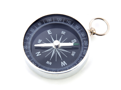
A magnetic compass is an instrument used to measure the Earth’s magnetic field and determine direction.

The magnetic compass installed in aircraft used to be primarily a simple device consisting of a directional magnet and a scale. Nowadays, instruments indicating direction are often derived from information obtained by a magnetic sensor located at the tip of the wing, known as a Horizontal Situation Indicator (HSI).

The direction displayed by the magnetic compass includes composite errors. Deviation represents the angle between the true North Pole and the magnetic North indicated by the compass. Variation is the angle between the magnetic North and the North indicated by the compass, also known as magnetic variation. The magnetic heading indicated by the compass is the sum of deviation and variation concerning the true North.

Errors also include dynamic errors that occur when the aircraft changes its heading or accelerates/decelerates.

Uses of Magnetic Compass

The magnetic compass installed in aircraft serves as an instrument to inform pilots about the heading of the aircraft. It has been used since the early days of aviation, comparing favorably to other instruments.

However, the direction indicated by the magnetic compass always includes errors such as deviation and variation. Pilots must correct these errors to determine the correct heading.

On the other hand, methods for aircraft to determine direction have advanced in various ways. Techniques such as relying on radio waves emitted from ground-based antennas to determine the aircraft’s position and direction or receiving signals from satellites for position and direction information have been developed and put into practical use.

Nevertheless, the magnetic compass remains an essential instrument, still installed in the cockpit today.

カテゴリー
category_usa

Fuel Tank

What Is a Fuel Tank?

Fuel Tank

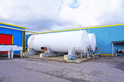
A fuel tank is a container used to store fuel for vehicles, aircraft, ships, and other machinery powered by engines.

In the case of many aircraft, they are equipped with fuel composed of a substance similar to kerosene.

Fuel tanks incorporate features such as a fuel inlet for refueling, a fuel pump to deliver fuel to the engine, and sensors to measure the amount of fuel inside the tank.

The shape, number, and mounting positions of fuel tanks in aircraft vary. In the case of a typical passenger aircraft, there are fuel tanks inside both wings. Some models also feature a central tank, mounted in the fuselage section that connects the left and right main wings, known as the central wing. For long-distance flights, certain passenger aircraft have fuel tanks installed in the fuselage and tail wing as well.

Uses of Fuel Tank

Aircraft fuel tanks are used to carry enough fuel for the aircraft to safely fly to its next destination.

In the case of passenger planes, the weight of the carried fuel constitutes a significant portion of the total weight of the aircraft. For long-distance flights exceeding 10,000 km, fuel can make up approximately 40 percent of the total weight of the aircraft.

During flight, the aircraft is lifted by the lift generated by both wings. This exerts considerable force on the wing roots where the wings attach to the fuselage. The weight of the fuel carried in the fuel tanks within the main wings acts as a force in the opposite direction of the lift on the wings during flight. Therefore, fuel tanks also play a role in minimizing the load on the wings during flight.

カテゴリー
category_usa

Fuel Gauge

What Is a Fuel Gauge?

A fuel gauge refers to the component or system in vehicles or machinery powered by engines that informs the user about the remaining fuel quantity.

In the case of aircraft, until around 1950, fuel gauges were similar to those in cars, using a float in the fuel tank to measure the fuel level based on the position of the float. However, contemporary aircraft primarily employ the capacitance type, which measures the change in the static capacitance of a capacitor immersed in fuel.

Many aircraft have multiple fuel tanks and capacitance sensors are installed in each tank. Data collected from sensors in each fuel tank is processed by a computer for fuel calculations, displaying the remaining fuel for each tank and the overall aircraft fuel quantity.

Uses of Fuel Gauge

The aircraft’s fuel gauge displays the remaining fuel in pounds, a unit of weight. Pilots and on-board computers use the remaining fuel information to determine how much distance can be covered.

As fuel decreases during flight, the overall weight of the aircraft decreases. With a lighter aircraft, the potential altitude for ascent increases, allowing for higher cruising altitudes and more fuel-efficient flights.

Additionally, when there is a significant difference in fuel levels between the left and right fuel tanks, it can adversely affect the stability of the aircraft. Pilots monitor the fuel levels in each tank to maintain proper balance and stability during flight.

Therefore, the fuel gauge serves not only to inform about the remaining fuel but also to understand the aircraft’s weight and balance for optimal flight performance.

カテゴリー
category_usa

Seaplane

What Is a Seaplane?

Seaplane

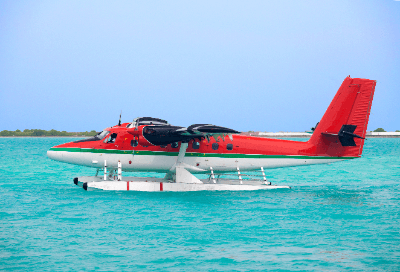
A seaplane is an aircraft capable of taking off and landing on the surface of bodies of water, such as the sea or a lake. Medium to large-sized seaplanes have a hull structure on the lower part of the fuselage, resembling that of a ship. This type of seaplane, often referred to as a flying boat, has a high-wing configuration with the main wings mounted on the top of the fuselage. Floats are attached underneath both wings, providing buoyancy and ensuring stability during water takeoffs, landings, and taxiing.

Lightweight small seaplanes have floats attached to the underside of the fuselage, allowing the aircraft to float. This type of seaplane is also known as a floatplane.

The US-2 rescue flying boat, manufactured by ShinMaywa Industries in Japan and operated by the Maritime Self-Defense Force, is a globally recognized high-performance seaplane. It can take off and land on rough seas with waves up to 3 meters high and is capable of operations on conventional runways.

Uses of Seaplane

Seaplanes, with their ability to take off and land on water, have a higher travel speed compared to ships and helicopters. This allows them to quickly reach distant destinations. Leveraging these capabilities, the Maritime Self-Defense Force’s US-2 rescue flying boat conducts search and rescue operations for individuals in distress at sea.

Seaplanes can land on water and quickly scoop up a large amount of water. Taking advantage of this capability, firefighting seaplanes engaged in aerial firefighting operations operate in foreign countries.

Moreover, seaplanes are used for transporting people and goods to remote islands without airstrips. They are also employed for transporting emergency medical patients from remote islands.

In addition, seaplanes serve military purposes as reconnaissance and liaison aircraft. The predecessor to the Maritime Self-Defense Force’s US-2, known as the PS-1, operated as an anti-submarine patrol aircraft.

カテゴリー
category_usa

Weather Station

What Is a Weather Station?

Weather Station

A Weather Station is an organizational name under the jurisdiction of the Japan Meteorological Agency, with regional weather stations located throughout the country. Each weather station collects meteorological data, creates weather forecasts, and disseminates meteorological information, including forecasts, on television and radio stations, as well as online networks.

For the safe operation of aircraft, meteorological information is crucial. Therefore, the Japan Meteorological Agency has established aviation weather stations and observation posts at 90 airports nationwide. Aviation weather stations provide not only general weather information but also data on phenomena such as turbulence and thunderstorms in monitored areas, predictions of visibility, cloud base height, and the potential for aircraft icing. This information is provided to aviation professionals.

Furthermore, meteorological information gathered from each aviation weather station is disseminated worldwide through the main office of the Japan Meteorological Agency.

Uses of Weather Station

Meteorological information is highly critical for the safe operation of aircraft. Each weather station, particularly aviation weather stations, provides meteorological information to aviation professionals. Specifically, this information includes temperature, humidity, cumulonimbus clouds, other cloud types, the occurrence of turbulence, rain, snow, wind direction and speed, visibility, cloud base height, and more.

This meteorological information is utilized to understand the weather above airports and along flight routes.

Dispatchers from airlines, responsible for planning flight operations, use meteorological information to formulate operational plans and may make decisions to cancel operations as necessary.

Airport controllers manage takeoffs and landings of aircraft while checking meteorological information around the airport.

Aircraft captains, based on meteorological information, collaborate with air traffic controllers and dispatchers to choose a safe route for timely flight operations.

カテゴリー
category_usa

Weather Radar

What Is a Weather Radar?
Weather Radar

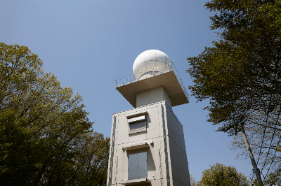
A Weather Radar is a radar used to observe cloud movements, rainfall patterns, snowfall, and other meteorological phenomena.

Meteorological agencies install weather radars in various locations on the ground, and airports are equipped with weather radars as well. Additionally, radars installed in aircraft serve the function of weather radar.

Weather radar emits radio waves into the atmosphere, and upon reflection from clouds or precipitation, the returning radio waves are received by the antenna. The time taken for the radio waves to reflect allows for the calculation of the distance to clouds or precipitation. The strength of the returning radio waves is used to determine the intensity of rainfall.

By analyzing the phase shift between emitted and received radio waves, it is possible to observe whether clouds or precipitation are approaching or receding. This phase shift, known as the Doppler effect, is utilized in Doppler radar.

Uses of Weather Radar

In the aviation industry, weather radar is employed for the safe operation of aircraft. Ground-based weather radar observes cloud movements within a radius of approximately 120 km, ensuring that hazardous clouds are not approaching during aircraft takeoff and landing.

Particularly beneath cumulonimbus clouds, strong downdrafts are likely to occur, and air traffic controllers take precautions, such as suspending aircraft takeoffs and landings, when cumulonimbus clouds are approaching near runways. On the other hand, weather radar installed in aircraft allows observation of clouds in the direction of travel.

If cumulonimbus clouds are ahead of the aircraft, pilots will alter the course. When turbulence is anticipated upon entering the clouds, pilots advise passengers and crew to take their seats and fasten their seat belts.

Principles of Weather Radar

Radar echo images display distributions such as the position of rain clouds and rainfall amounts, enabling the estimation of meteorological phenomena. Echo images can observe meteorological phenomena not visible in visible and infrared cloud images from weather satellites. In echo images, precipitation is often classified by color, allowing for the estimation of rainfall patterns from intensity distributions.

The temporal changes in echo images reveal the characteristics of meteorological phenomena. Colored areas are referred to as precipitation areas, and the onset and movement of precipitation areas are used to estimate weather patterns.

Types of Weather Radar

There are primarily five types of weather radar: microwave radar, millimeter-wave radar, Doppler radar, polarimetric radar, and lightning radar.

1. Microwave Radar

Analyzes electromagnetic waves reflected by crystals such as rain or snow to observe the density and position of precipitation like snow and rain. It uses electromagnetic waves with a wavelength of 3 to 10 cm.

2. Millimeter-Wave Radar

Analyzes millimeter waves with a wavelength of about 1 mm to 10 mm, similar to microwave radar.

3. Doppler Radar

Observe frequency shifts due to the Doppler effect by emitting radio waves. It can measure wind direction and speed and observe the flow and movement of air and clouds on a fine scale. It is suitable for observation during rough weather, but in clear weather, wind cannot be observed as there are no raindrops.

4. Polarimetric Radar

Emits both horizontal and vertical polarized waves and determines precipitation intensity by the difference in the reflectivity of the waves.

5. Lightning Radar

Analyzes reflected electromagnetic waves and can also observe lightning.

How to Choose Weather Radar

Weather radar selection depends on factors related to observation and estimation.

1. Microwave Radar

Observe shadow areas that are challenging to observe due to obstacles, making them suitable for installations in mountainous areas. It has become compact and lightweight and is also deployed on weather satellites, which are less affected by ground obstacles due to their wide observation range.

2. Millimeter-Wave Radar

With a shorter wavelength, it can observe small objects and is suitable for observing particles in fog and cloud droplets. It is used not only in ground-based installations but also on weather satellites.

3. Doppler Radar

Grasps wind direction and speed to observe the flow and movement of air and clouds on a fine scale. It is suitable for observation during rough weather, but in clear weather, wind cannot be observed as there are no raindrops.

4. Polarimetric Radar

Less affected by factors such as raindrop size and transmit power, allowing for quantitative observation.

5. Lightning Radar

Since thunderstorms interfere with other observations, their use is limited. For lightning observation, a separate radar may be installed.